


The Rebirth of the Kottappuram Fort (Cranganore Fort)
- Benny Kuriakose

- Oct 24, 2022
- 8 min read
Updated: Oct 24, 2022
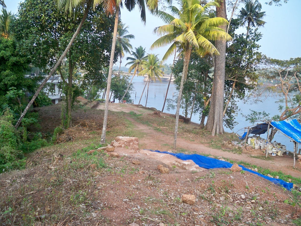
The view of the Kottappuram Kotta in the village of Methala in the Thrissur district of Kerala materialises where the smooth waves of the Periyar River meet the expansive Arabian Sea. It sits quietly, as if retired, about a kilometre from the bustling Kottappuram market; the unkempt ferns growing wildly on the walls and the laterite steps tell stories of a youth that endured captivity, violence, and triumph. The excavation and conservation process brought the dying fort back to life, not as the walls that protect the city from invasions but as the ones that echo the past, lying in deep slumber beneath the soil.

Lists of Contents
1. The History of the Kottappuram Fort

The Muziris Port dates back to Before Christ era, and this is the land where the Jews, Dutch, Portuguese, Chinese, and Arabs came to this place. It established the Indo-Roman and Indo-Greek trade channels, which attracted more traders from across the globe. They mostly traded in gold, metals, spices, pepper, gemstones, and textiles. Thus, the port bustled with trading ships from the Arabian Sea and efficiently regulated ships entering the coast of Malabar, thus becoming a prominent centre for trade.


The Kottappuram Fort (Cranganore Fort as in some other records) was pivotal to the development of Muziris and shielded against the invasion of Tipu Sultan. Its strategic position guarding the mouth of the river first caught the eye of the Portuguese, who built the fort in the year 1523 AD, which was later captured and destroyed by the Dutch in 1662 AD. The Dutch used the fort as an outhouse to guard the trade ships. The Portuguese slaves and the tribes from nearby villages were involved in making the fort. The Travancore King negotiated with the Dutch to purchase Kottappuram and Pallippuram forts.

It saw numerous battles, including one between the Zamorins and the Ruler of Cochin, which caused various shifts in the cultural and political fabric. The fight between the Portuguese and the Dutch was destructive and resulted in heavy damage. The fall and rise of Kottappuram also led to considerable structural modifications during each historical era, which brought about a potpourri of diverse architectural influences.

2. The Discovery of Walls and Artefacts
The Kottappuram Fort was excavated in three stages starting in 2009 and was conserved as part of the Muziris Heritage Project. It was done using an excavation method called sondages, where a test excavation is done first to understand the stratigraphy of the soil, and a deeper excavation is done later. This was a protected monument under the State Department of Archaeology, Government of Kerala. The objective of the excavation process was to find artefacts and remnants of the old fort.


From the Kottappuram Fort debris, the thick walls were gathered as high as eighteen feet, built using large laterite stones, sea rocks, granite stones, big clay bricks, and liquefied limestone for pavements. It also comprised two bastions and an arched cellar built over a mud-rammed floor. Storerooms, a large munition room, and garrison grounds occupied most of the fortified area.


The artefacts include coins, door hinges, clamps, stone and iron cannon balls, different types of nails, etc. Other remnants on-site include roof tiles, bricks from a foreign source, and square-shaped floor tiles. The presence of lime from the mortar helped preserve the skeletal remains underneath. One could discern the dynamics of the past within the fortified walls by the extent of the magnitude of destruction.


3. The Route Map to Kottappuram Fort
The pathway goes in a clockwise manner with separate entry and exit.

4. Important Areas Excavated from the Fort Site
Dutch Structure (Location 01) :
The northern fortification wall was built by the Dutch and is the Kochi-Travancore political boundary called Ko-Ti Kallu.

Early Excavation (Location 02) :
The trial excavation of 2009 led to the discovery of steps and a massive laterite wall and is to be refilled to an offset level.
Eastern Bastion (Location 03) :
The Dutch Bastion and a few Portuguese remains were discovered. The depth of the foundations goes up to the water level.
Dutch Building (Location 04) :
The steps have a Portuguese style, whereas the walls have a Dutch character. The north-west quadrant has been reburied to step level, and the northern portion must be consolidated. Extended burials were also found at the location.

Living Area (Location 05) :
The Dutch Building can be identified by the mud floor, steps, drainage, rooms, pillar base, beam sockets etc.

Tomb or Skelton (Location 06) :
Skeletal remains were found in the trench.

Trench Details (Location 07) :
The Dutch structure was built over a cenotaph and was vandalised.

Southern Bastion (Location 08):
The round bastion of the Portuguese was modified by the Dutch.

Rectangular Hall (Location 09):
A rectangular hall with the main entrance to the east and the windows to the north. A vaulted cellar and rectangular chamber with steps are also discovered from this location.

Findings (Location 10):
Tiles, bricks, laterite blocks, and pottery were discovered at the location.

5. Kottappuram Fort Before Conservation
The site was in a completely damaged state. The walls have fallen down, leaving a mound of laterite deposit over the decay. The vegetation on site aggravates the decaying process and poses a threat to the site. The lime from the mortar creates an environment suitable for plant growth. A foundation stone installed by the Department of Archaeology in 1909 and an existing building within are additional structures found before excavation.


A huge portion of the bastion wall was dilapidated, except the northern and southern ends. Hence, the conservation of the fort is crucial to revitalising the historic fabric of Kodungallur.
6. How were the Ruins formed?
The term "ruins" refers to a building that was previously stable and functional but collapsed over a period of time for various reasons, such as neglect, natural calamities, lack of maintenance, human destruction, etc.


When a structure is neglected and not used, the first stage of deterioration starts. Prolonged years of disuse causes roof tiles to loosen and fall. Plant growth is attracted to the lime found in joints, and the roots begin to penetrate the masonry. The structure is further degraded by the infiltration of water. These factors can cause the structure to fail, which leads to its collapse. When the roof collapses, water enters the building, which accelerates further degradation. The upper course of the wall collapses due to soil accumulation coming down from the slope, and masonry blocks pile inside the building as a result.
Under the destroyed structure, masonry units and soil build up to form fairly stable conditions. Deep-rooted plants and bushes, however, easily inhabit the loose debris and, as they develop, take advantage of the walls. After excavation, these ruins need to be handled using the proper corrective actions.
7. The Conservation Objective and Methodology
The conservation process, initiated with the motive to conserve and interpret the Kottappuram Fort, was done in a schematic manner. The conservation does not intend to rebuild the Fort, but rather to keep it as it is in the dilapidated form, as if stuck in the past. This will give a clear picture of the horrifying past that broke down the fort while retaining the historic fabric.
The conservation of project has taken into consideration the socio-political, cultural, and historic relevance of the Fort. The conservation process was formulated to ensure the sustenance of the historic fabric. A survey and documentation of the building were done to understand the cause of decay, which in turn helps to find a solution to the issue. From the study done, a proposal was formulated for the interpretation of the Fort as a museum.
8. Site Conditions on Fort Site
Rainfall was a major concern which aggravates the decaying process of the structure. It also facilitates the wild growth of vegetation through fractures or voids. It also leads to ponding of the site, which needs to be drained and land must be sloped to create a route for water flow.
The site has a gradual slope towards the north and east and a steep slope towards the west and south of the site. The fallen debris from the fort formed a huge mound of laterite soil.
The site was home to various species of local trees, including Anjili, Sandalwood, Coconut, Njaval, etc., and also consists of herbs and shrubs. Trees closer to the structures that posed a threat were cut.
9. The Common Defects on the Fort Walls

Broken wall tops and ends allow water to seep through the walls.
Voids on walls affect the structural stability, which is caused by either degradation of mortar or loss of masonry blocks.
Fractures that are stable and live.
Decay of lower course and masonry units is prone to weathering and erosion.
Weathering of mortar and plaster.
Vegetation growth on cracks, fractures and voids.
10. Techniques for Conservation of the Fort
Reburial
The process of reburial protects the building from further deterioration due to exposure. The warehouse was reburied to prevent people from walking over it and collapsing due to weight.
Consolidation
Additional strengthening is provided by means of grouting or other structural elements. The masonry walls were consolidated to prevent further weathering.
Grouting: The process of filling voids with mortar.
Underpinning: It involves providing reinforcement to existing foundations.
Stitching involves drilling across the fracture by blowing out the debris with a drinking straw, cleaning it up with a water bottle brush, and grouting the stitch.


11. Protective Enclosures
The enclosures that partially or fully cover the portions of the fort that are prone to deterioration from rain or other agents. Trenches and gunpowder rooms have protective enclosures.


12. The Remedial Measures Taken for Conservation of the Kottappuram Fort Wall
1. Broken wall tops were consolidated.
2. Soft capping is done instead of hard capping as it protects the wall better from water penetration.

3. Broken wall ends were analysed, and ferro-cement will be used for structural support. Vertical, stepped/ramped, and overhanging are the three types of wall ends.

4. Voids are remedied by grouting.


5. Underpinning, physical stitching, or grouting are done to fix fractures.
6. Decay of lower course is further prevented by sloping down away from the building with a minimum distance of 1.2 metres.

7. If a masonry unit is decayed, a block that is similar to the original character replaces the decayed one.


8. Floors and weathered masonry are protected by enclosures to prevent further exposure.
13. The Proposals for the Fort Museum
By means of signage and way-finding, an interpretation museum is part of the final proposal for Kottappuram Fort. Lighting, toilets, and seating are also proposed to ease movement. Rough granite slabs are used for pavements with minimal landscape intervention. Coconut palms are planted for their shallow roots. A boat jetty is also built next to the fort for accessibility by water.
The route begins at the south and north bastion walls of the warehouse by passing through the trenches and gun powder room. Information panels provide information regarding the history of the fort. It follows a storyline starting with the introduction, history, fort remains, and conclusion from the entrance to the exit. The panels also provide information about the local wildlife and Archaeological excavations on site. The project also proposes interactive excavation sites for sites that are already unearthed.
14. Conclusion: The Present Condition of Kottappuram Fort

The conservation done by Benny Kuriakose and Associates on the Kottappuram Fort gives a new meaning to a structure that was just isolated masonry forms that made no sense, excavated from Kodungallur. The arched enclosures not only conserve the structures but are also aesthetically pleasing, which makes the space a welcoming one. Shortly, the museum which will be opened will help visualise the lost elements of the fort, from a tiny sample of building materials to the impact it created on Kerala.


Visit the links given below, to read some of our blogs:
References :
John Ashurst, Conservation of Ruins, 2007.
Pramod Joglekar and Jayshree Mungur-Medhi, Animal Remains from Kottappuram Fort Excavation, Thrissur District.
A Blog by Anuradha Shankar, A Wandering Mind, Kottapuram Fort and Some Thoughts on Archaeology in India Today.


Really helpful post on self-care practices your tips were practical and easy to implement. I also found a discussion on https://theshelfking.com mental wellness, which complemented your advice.
شيخ روحاني
رقم شيخ روحاني
شيخ روحاني لجلب الحبيب
الشيخ الروحاني
الشيخ الروحاني
شيخ روحاني سعودي
رقم شيخ روحاني
شيخ روحاني مضمون
Berlinintim
Berlin Intim
جلب الحبيب
https://www.eljnoub.com/
https://hurenberlin.com/
youtube